• Skip to primary navigation
  • Skip to main content
Ashokan Watershed Stream Management Plan logo

ashokanstreams

Ashokan Watershed Stream Management Plan

  • About Us
    • Our Team
    • Action Plans
    • Ashokan Watershed Stakeholder Council
    • Working Groups and Committees
    • Employment Opportunities
  • Areas of Focus
    • Assistance to Streamside Landowners
    • Enhancing and Protecting Water Quality
    • Floodplain Management
    • Improving Aquatic and Riparian Habitat
    • Increasing Public Access to Streams
    • Streamside Infrastructure
  • Explore the Watershed
    • Stream Recreation and Activities
    • Esopus Creek
    • Beaver Kill
    • Birch Creek
    • Broadstreet Hollow Creek
    • Bush Kill
    • Bushnellsville Creek
    • Fox Hollow Creek
    • Little Beaver Kill
    • Peck Hollow Creek
    • Stony Clove Creek
    • Warner Creek
    • Woodland Valley Creek
  • Projects & Funding
    • Featured Projects
    • SMIP Funding for Infrastructure Improvements
    • SMIP Project Insurance Requirements
    • Copyrights and Access to Information
    • Subcontractor Approval Policy
  • Conferences & Training
    • Catskill Environmental Research & Monitoring Conference (CERM)
    • Ashokan Watershed Conference 2017
    • Ashokan Watershed Weekend Events — Summer 2020
    • Ashokan Watershed Month
    • Stream Explorers Youth Adventure Day
    • Past Conferences
  • Publications & Resources
    • Technical Data & Resources
    • Stream Management Plans
  • News & Events
  • Contact Us
  • Show Search
Hide Search

Peck Hollow Creek

Peck Hollow Creek
Peck Hollow Creek

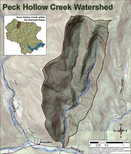
Peck Hollow’s headwaters begin on the sides of Mount Sherrill and North Dome Mountains in the Town of Lexington in Greene County, flows through the Hunter-Westkill Wilderness Area and the Shandaken Wild Forest (in the Town of Shandaken, Ulster County) before meeting Peck Hollow Road. From here the road closely follows the stream until it empties into the Esopus Creek. The size of the Peck Hollow Watershed is 5 square miles and the length of the main stem channel is 5.1 miles.

Peck Hollow Creek has not yet been assessed. A full report on Peck Hollow Creek conditions and management recommendations will be available on this website when it becomes available.

map of Peck Hollow Creek
Click to view larger image.
Ashokan Watershed Stream Management logo (in white)

Footer

Ashokan Watershed Stream Management Program

PO Box 667
3130 State Route 28
Shokan, NY 12481
845 688 3047
845 688 3130 (fax)

Copyright © 2023 ·

Keep In Touch

  • Facebook
  • Instagram
  • Twitter
  • YouTube
  • Homepage
  • About Us
  • Areas of Focus
  • Explore the Watershed
  • Projects & Funding
  • Conferences & Training
  • Publications & Resources
  • News & Events
  • Contact Us