• Skip to primary navigation
  • Skip to main content
Ashokan Watershed Stream Management Plan logo

ashokanstreams

Ashokan Watershed Stream Management Plan

  • About Us
    • Our Team
    • Action Plans
    • Ashokan Watershed Stakeholder Council
    • Working Groups and Committees
    • Employment Opportunities
  • Areas of Focus
    • Assistance to Streamside Landowners
    • Enhancing and Protecting Water Quality
    • Floodplain Management
    • Improving Aquatic and Riparian Habitat
    • Increasing Public Access to Streams
    • Streamside Infrastructure
  • Explore the Watershed
    • Stream Recreation and Activities
    • Esopus Creek
    • Beaver Kill
    • Birch Creek
    • Broadstreet Hollow Creek
    • Bush Kill
    • Bushnellsville Creek
    • Fox Hollow Creek
    • Little Beaver Kill
    • Peck Hollow Creek
    • Stony Clove Creek
    • Warner Creek
    • Woodland Valley Creek
  • Projects & Funding
    • Featured Projects
    • SMIP Funding for Infrastructure Improvements
    • SMIP Project Insurance Requirements
    • Copyrights and Access to Information
    • Subcontractor Approval Policy
  • Conferences & Training
    • Catskill Environmental Research & Monitoring Conference (CERM)
    • Ashokan Watershed Conference 2017
    • Ashokan Watershed Weekend Events — Summer 2020
    • Ashokan Watershed Month
    • Stream Explorers Youth Adventure Day
    • Past Conferences
  • Publications & Resources
    • Technical Data & Resources
    • Stream Management Plans
  • News & Events
  • Contact Us
  • Show Search
Hide Search

Bush Kill

Bush Kill Creek

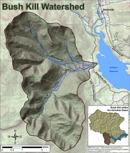
Located almost entirely in the Town of Olive, the Bush Kill is one of the few streams in our area that drains directly into the Ashokan Reservoir. The Bush Kill begins in the undeveloped Sundown Wilderness Area and its headwaters drain several nearby mountains including: Ashokan High Point, Mombaccus, Little Rocky, and Hanover Mountains. The Bush Kill watershed is 19.6 square miles. The Bush Kill mainstem flows 7.6 miles north. The Bush Kill is joined by several tributaries including Kanape Brook, South Hollow Brook, Mine Hollow, Maltby Hollow Brook, and Dry Brook. The stream is paralleled by Ulster County Route 42 for much of its length before ending in West Shokan, where it flows into the Ashokan Reservoir.

In 2012, Ulster County Soil & Water Conservation District technicians, with assistance from interns from the Student Conservation Association and Ulster County Community College, did a stream assessment along the Bush Kill. The assessment focused on the area along County Route 42 from Kanape Brook downstream to the reservoir. During the walkover, the team inventoried erosion hazards, suspended sediment sources, woody debris hazards, and culverts. While roughly 98% of the watershed is forested, the major impairments for the creek are related to development in the valley bottom. Observations made during the assessment suggest that the stream’s interaction with transportation infrastructure, including road embankments, culverts, and bridges in the tight valley place high stress on the creek’s morphology and water quality.

map of Bushkill Creek
Click to view larger image.

A full report on Bush Kill conditions and management recommendations is available:

Bush Kill Stream Management Plan (hi-res, 42 MB)
Bush Kill Stream Management Plan (low-res, 20 MB)

A report on conditions and management recommendations for the Maltby Hollow Creek tributary to the Bush Kill is available here:

Maltby Hollow Brook Stream Feature Inventory and Management Recommendations (hi-res, 54 MB)

Ashokan Watershed Stream Management logo (in white)

Footer

Ashokan Watershed Stream Management Program

PO Box 667
3130 State Route 28
Shokan, NY 12481
845 688 3047
845 688 3130 (fax)

Copyright © 2023 ·

Keep In Touch

  • Facebook
  • Instagram
  • Twitter
  • YouTube
  • Homepage
  • About Us
  • Areas of Focus
  • Explore the Watershed
  • Projects & Funding
  • Conferences & Training
  • Publications & Resources
  • News & Events
  • Contact Us