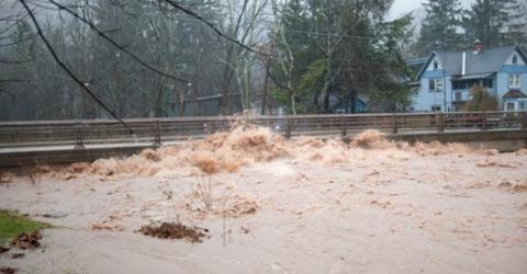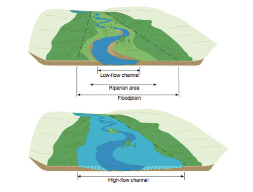
Floods are a fact of life in the Ashokan Watershed. Most recently in 2011, the massive damage caused by Tropical Storms Irene and Lee made this even more apparent. It’s important to remember when looking at a stream peacefully flowing within its channel that at high flows, the stream occupies the land adjacent to the channel called the “floodplain.”
Historically, small communities in our steep, mountainous region have been situated on or near large floodplains, sometimes at stream confluences. Our challenge now is to manage and reduce the risk of flooding and erosion to communities. One way to approach this is to maintain the ability of streams to move water, sediment, and debris through populated areas while using the natural capacity of floodplains to store water and reduce hazards elsewhere in the stream system.
Communities and property owners can take action to reduce flood risks, including: 1) avoiding future development in areas subject to repetitive flood damages; 2) flood proofing and elevating structures to reduce damages where existing infrastructure is at risk; and 3) developing early warning systems, flood response plans, and community flood mitigation plans.
See below for information on flood insurance, flood mitigation funding programs and flood hazard maps.
Recently, AWSMP provided funding to the Town of Shandaken to create a Flood Mitigation Plan for the greater Shandaken community. Over the next few years, AWSMP will expand assistance to watershed municipalities for local flood hazard mitigation.
AWSMP also provides assistance with flood recovery and response following major flood events. Following Tropical Storms Irene and Lee, Ulster County Soil & Water Conservation District technicians assisted highway departments and the National Guard with restoring streams back into their original channels and creating designs to help alleviate future flooding. Cornell Cooperative Extension of Ulster County employees provided guidance to area landowners and worked with local code enforcement officers and building departments to determine the appropriate scale of damages for submittal of claims to FEMA. Water flows onto the floodplain during a high water event.

Water flows onto the floodplain during a high water event.
Flood Insurance
The National Flood Insurance Program (NFIP) offers flood insurance to homeowners, renters, and business owners. Participation in the NFIP is based on an agreement between communities and the Federal government. Through the NFIP, the Federal Emergency Management Agency (FEMA) provides maps of hazardous areas and provides federally backed flood insurance. In return, communities agree to enact and enforce floodplain regulations intended to minimize the threats to life and property. All communities in the Ashokan Watershed participate in the NFIP.
In July 2012, the U.S. Congress passed the Biggert-Waters Flood Insurance Reform Act of 2012 (BW-12) which calls on the Federal Emergency Management Agency (FEMA), and other agencies, to make a number of changes to the way NFIP is run. Some of these changes already have occurred, and others will be implemented in the coming months. Key provisions of the legislation will require the NFIP to raise rates to reflect true flood risk, make the program more financially stable, and change how Flood Insurance Rate Map (FIRM) updates impact policyholders. The changes will mean premium rate increases for some—but not all—policyholders over time. Homeowners and business owners are encouraged to learn their flood risk and talk to their insurance agent to determine if their policy will be affected by BW-12. For more information visit FEMA’s website on NFIP changes.
Flood Mitigation Funding Programs
Tropical Storms Irene and Lee as well as Superstorm Sandy struck our region hard over the past few years. In response to the destruction they caused, various levels of government (federal, state and local) have allocated money to grant programs to help with recovery and revitalization.
Recreate NY Smart Home Program
If Superstorm Sandy, Hurricane Irene or Tropical Storm Lee damaged your residential property, you may be eligible for financial assistance to elevate your home, which can reduce flood insurance rates. To apply for financial assistance, visit the Recreate NY Smart Home website and click on the “Apply Here” button, or call 1-855-NYS-Sandy
Funding Available: $663 million on a first come, first-served basis.
Eligibility: Homeowners and business owners in Ulster and Sullivan counties.
Match Required: No
Administered by: New York State Department of State
Website: http://www.nysandyhelp.ny.gov/
Hazard Mitigation Grant Program (HMGP)
The Hazard Mitigation Grant Program (HMGP) provides grants to states and local governments to implement long-term hazard mitigation measures after a major disaster declaration. The purpose of the HMGP is to reduce the loss of life and property due to natural disasters and to enable mitigation measures to be implemented during the immediate recovery from a disaster. The HMGP is authorized under Section 404 of the Robert T. Stafford Disaster Relief and Emergency Assistance Act.
Funding Available: Varies by disaster declaration.
Eligibility: State and local governments.
Match Required: 25% local share
Administered by: Federal Emergency Management Agency and New York State
Website: http://www.fema.gov/hazard-mitigation-grant-program
Local Flood Analysis (LFA)
Local Flood Hazard Mitigation Analysis is a New York City funded program developed at the request of West of Hudson NYC Watershed communities. The program funds a two-step process to conduct engineering analysis to determine the causes of flooding and evaluate mitigation options articulated in a flood hazard mitigation plan, followed by project design and implementation.
Funding Available: $2,000,000 in the Ashokan Watershed for eligible population centers.
Eligibility: Open only to eligible West-of-Hudson NYC Watershed communities.
Match Required: No
Administered by: Cornell Cooperative Extension of Ulster County and Ulster County Soil and Water Conservation District.
Website: Contact local Stream Management Program offices for additional details.
NY Rising Community Reconstruction Program
This is a New York State program whose purpose is to develop comprehensive local rebuilding plans for specified communities affected by Irene, Lee and Sandy. Funds will also be used to implement measures identified in approved plans.
Funding Available: $3 million for Town of Shandaken; up to $3 million for other Ulster County Communities.
Eligibility: Town must develop a CRZ plan to access implementation funds.
Match Required: No
Administered by: NYS Department of State
Website: http://nysandyhelp.ny.gov/community-reconstruction-program
Flood Hazard Maps
The National Flood Insurance Act of 1968 directed the federal government to identify all flood prone areas within the United States and establish risk zones within those areas. In response, FEMA created maps depicting areas modeled to have a higher risk of flooding. (Areas not in mapped zones can still flood!) The maps are called Flood Insurance Rate Maps, although most people simply know them as FIRMs.
The FIRMs depict areas subject to additional regulations because of the flood hazards, or the “regulated floodplain.” As part of the National Flood Insurance Program (NFIP), the federal government provides FIRMs and flood insurance to communities that agree to regulate development in high-risk flood areas. FIRMs form the basis for federally back flood insurance rates.
FEMA recently updated FIRMs for parts of Ulster County. Preliminary FIRMs, Flood Insurance Study (FIS) reports, and FIRM databases are available to towns in the Ashokan Watershed. In the coming months, municipalities will be reviewing the maps and considering them for adoption. Ulster County has provided a fact sheet explaining NFIP and FIRM revisions for residents.
Preliminary Flood Insurance Rate Maps (FIRMs)
Preliminary FIRMs can be viewed with parcel boundaries on the Ulster County Parcel Viewer. The Preliminary FIRMs and Flood Insurance Study for the Ashokan Watershed are available as pdfs for download. (These are large files and may take some time to download.) Printed maps are available at your Town Hall.
- 36111C0540E-Wawarsing-Brandy Brook
- 36111C0545E-Wawarsing-RondoutReservoir-FarEast
- 36111C0575E-Rochester-Vernooy_Kill-section
- 36111C0700E-Wawarsing-BeerKill
- 36111CIND0B-Ulster_County_complete-map-panels
- 36111C0040E_Shandaken_AltonCreek-BirchCreek
- 36111C0045E_Shandaken_Bushnellsville_Creek
- 36111C0065E_Shandaken_Broadstreet_Hollow_upper_portion
- 36111C0350E-Hardenburg_Beaverkill_upper-portion
- 36111C0150E_Hardenburg_Beaverkill
- 36111C0200E_Hardenburg-Dry_Brook
- 36111C0205E_Shandaken_Birch-Esopus_confluence
- 36111C0210E_Shandaken_Fox_Hollow
- 36111C0215E_Shandaken_Esopus_Creek-upper-portion-Winneesook
- 36111C0220E-Shandaken_Pantherkill_upper-portion
- 36111C0230E-Shandaken_BroadstreetHollow_WoodlandValley_StonyClove_Esopus
- 36111C0235E-Shandaken_StonyClove-WarnerCreek
- 36111C0240E-Shandaken_WoodlandValley-upper-portion
- 36111C0245E-Shan-Olive-Woodstock_Esopus_Beaverkill
- 36111C0255E-Woodstock_Beaverkill
- 36111C0260E-Woodstock_MinkHollow
- 36111C0265E-Woodstock_LittleBeaverkill
- 36111C0350E-Hardenburg_Beaverkill_upper-portion
- 36111C0365E-Denning_WestBranchNeversink-upper_portion
- 36111C0370E-Denning_EastBranchNeversink
- 36111C0375E-Denning_WestBranchNeversink_Frost-Valley
- 36111C0390E-Denning_RondoutCreek-Sundown
- 36111C0395E-Denning_RondoutCreek_mid-section
- 36111C0400E-Denning_EastBranchNeversink_upper-portion
- 36111C0405E-Denning_RondoutCreek-UpperPortion_Olive-Bushkill
- 36111C0410E-Olive_Bushkill_lower-portion
- 36111C0425E-Olive_Bushkill_upper-portion
- 36111C0430E-Olive_AshokanReservoir_middle
- 36111C0435F-Hurley_AshokanReservoir_east
- 36111C0440E-Marbletown_LowerEsopus
- 36111C0455F-Hurley_AshokanReservoir-FarEast
- 36111C0530E-Wawarsing_RondoutReservoir
- 36111C0535F-Rochester-Vernooy_Kill
