Although officially named Woodland Creek, this stream is locally referred to as Woodland Valley Creek. Running along Woodland Valley Road, the Woodland Valley Creek flows through an area with a wealth of natural resources, recreational activities, and brimming with local history. Easily accessible fishing access sites, primitive and car camping locations, and numerous trailheads make this one of the most popular recreational areas in the entire Ashokan Watershed.
Settled since the early 1800s, Woodland Valley, formerly known as Snyder Hollow, hosted a large tannery (Snyder tannery) and two channel-spanning sawmills during the latter half of the 1800’s when this watershed was extensively logged. During the heyday of the tannery industry, hundreds of people occupied this valley seeking to extract a substance known as tannin from the bark of the abundant hemlock trees in the area. Tannin is an integral compound in the process of tanning leather products and was a huge industry in the area during the late 19th and early 20th centuries. A number of roads used by the hemlock harvesters (called bark peelers) can still be seen today and some of these “bark roads” have been repurposed as hiking trails. Following the collapse of the tanning industry, Woodland Valley hosted popular late 19th and early 20th century resorts (Roxmoor and Lord’s). Postcards from that time show a bucolic, “manicured” valley that has since recovered its natural wild state.
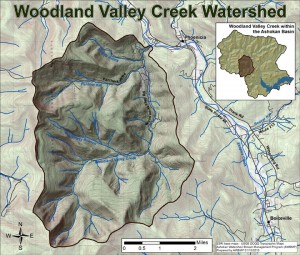
Woodland Valley Creek is 7.5 miles in length with a drainage area of approximately 20.5 miles. The headwaters of the stream begin along the steep slopes of some of the tallest mountains in the Catskills including: Slide, Wittenburg, Panther, and Cornell mountains. Woodland Valley Creek joins the Esopus Creek near the bridge at Herdman Road. This confluence is a popular location for fishing, kayaking and swimming. Some of the larger and more notable tributaries to Woodland Valley Creek include: Daugherty Brook, Cross Mountain Hollow Brook, Panther Kill and Muddy Brook. It is also home to the Woodland Valley Campground (one of the oldest public campgrounds in New York State) and many acres of State Forest Preserve land with plentiful opportunities to hike, fish, hunt, and camp as well as just enjoying the great outdoors.
Woodland Valley watershed is a typical Catskill Mountain watershed in a geologically unique setting. Woodland Creek and the reaches of Esopus Creek above Phoenicia, inscribe a circle around the base of Panther Mountain. The watershed contains steep mountain drainages with fast, boulder-filled runs and moderately meandering riffles and pools, ricocheting across valley walls and developed land. A significant amount of Town infrastructure is located in the Woodland Valley and Woodland Creek was the second highest contributor of suspended sediment load among all tributaries to the Esopus Creek from 2010-2011.
From 2009-2010, the Ashokan Watershed Stream Management Program worked with the Town of Shandaken on a large streambank stabilization project on Woodland Valley Creek just below Fawn Hill Bridge. The Town of Shandaken was concerned about Woodland Valley Road washing out, with the potential to cut off access to 100 residents. This project demonstrates a 152-ft stacked rock wall pinned to the underlying bedrock, and state of the art bio-engineering on the hill slope above the wall. The site withstood floods in 2010 and the deluges of Tropical Storms Irene and Lee in 2011.
Ulster County Soil & Water Conservation District staff completed a two-year assessment of the Woodland Valley Creek in 2007-2008. The stream was reassessed in 2015.
A full report on Woodland Creek conditions and recommendations is now available:
Woodland Creek Stream Management Plan