Phoenicia Bridge Street Bridge Replacement Project
This webpage provides updates and information about the Bridge Street Bridge Enlargement Project underway in Phoenicia, NY. The Bridge Street bridge passes over the Esopus Creek, connects Main Street with High Street, and is one of several entrances to downtown Phoenicia. Learn more about the history of the Bridge Street bridge and replacement project below.
Announcements and Quick Links
Bridge Street Bridge Design Feasibility Report
Read the Bridge Street Bridge design report from project engineer SLR Consulting. Each of the five bridge alternatives explored are presented in the report.
Public Meeting #2
A Public Informational Open House was held June 12 and June 13 at the Parish Hall of St. Francis De Sales in Phoenicia. The public was invited to stop by and view displays of bridge alternatives. Project design engineers and Ulster County representatives were on hand to answer questions about the bridge project and to gather public input.
Now is the time to express your thoughts and concerns, ask questions, and provide input on the future of the project.
Let us know what you think!
Take the public comment survey to provide input to project managers. Or submit questions or comments about the project at any time via email phoeniciabridge@slrconsulting.com.
Public Meeting #1
The first Public Informational Meeting for the Bridge Street Bridge Replacement Project was held February 6, 2023, at the Shandaken Town Hall.
Presentation slides: https://www.shandaken.us/wp-content/uploads/2023/02/Phoenicia-Bridge-Meeting-2023-02-06-2.pdf
Meeting video: https://www.youtube.com/watch?v=LgMXsMqdNrY
Posts with meeting information:
https://shandaken.us/news/phoenicia-bridge-street-bridge-replacement-info/
https://ashokanstreams.org/design-options-for-the-phoenicia-bridge-street-bridge/
The Bridge Street Bridge Replacement Project
In 2016, the Town of Shandaken completed a Local Flood Analysis for the Hamlets of Phoenicia and Mt. Tremper. The flood analysis recommended that Ulster County explore replacement of the Bridge Street bridge as one of multiple actions that may reduce flood impacts in Phoenicia. The Ulster County Department of Public Works has since begun a project exploring the benefits of different bridge replacement designs.
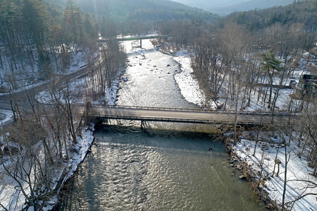
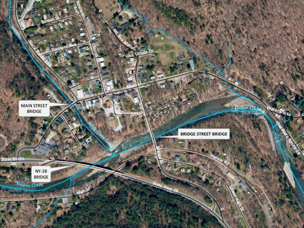
Bridge Description and Location
The existing bridge was constructed in 1976 and is composed of three spans, a composite steel girder and reinforced concrete deck superstructure with a substructure of two pile-supported stub abutments with two piers. The bridge’s width is 31 feet and 9 inches and carries two 13-foot-wide travel lanes, one in each direction.
The Bridge Street bridge crosses Esopus Creek approximately 500 feet downstream of where the Stony Clove Creek flows into the Esopus Creek. Bridge Street intersects Main Street about 500 feet north of the bridge. To the south, the bridge connects Phoenicia with State Route 28. On the southern bridge approach there are several intersecting side streets, including Station Road, High Street, and Lower High Street. The Empire State Rail Museum and Rail Explorers are located on the east end of Station Road near Lower High Street.
Bridge History
Based on historical data two different bridges have been used at this site. The original bridge was a two-span truss present from 1898 to 1976 with a total bridge length of 216 feet. The bridge width was approximately 22 feet 6 inches wide with an 18-foot roadway and a sidewalk.
The current bridge has been providing an entrance into Phoenicia since 1976 when the original truss was removed. The current Bridge Street bridge carries an 8-inch potable water main owned by the Phoenicia Water District that supplies customers located on the south side of Esopus Creek with drinking and fire-fighting water.
The engineering firm Peak Engineering studied the bridge in March 2012 after it was severely damaged during Tropical Storm Irene in August 2011. The bridge was closed to traffic until repairs were completed.
Flood Damage
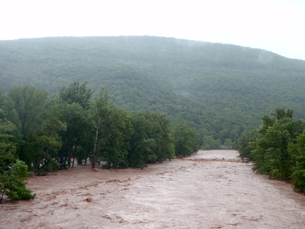
The bridge has been overtopped and damaged by floodwaters in the past, most notably during Tropical Storm Irene in 2011.
Past computer modeling indicates the existing bridge overtops in floods greater than the 10-year magnitude. A 10-year flood has a 10% chance of being exceeded in any given year. Since the bridge was constructed in 1976, there have been six floods on Esopus Creek exceeding the 10-year magnitude flow recorded by the nearest stream gauge in Allaben. This means in the last 50 years the bridge may have overtopped at least six times.
On April 2, 2005, flows in the Esopus Creek at Allaben reached an approximately 50-year flood, while flows in the Stony Clove Creek were between a 25- and 50-year flood. During Tropical Storm Irene in August 2011, the Bridge Street bridge was overtopped by several feet of floodwaters and significantly damaged. Forces against the bridge were so severe that the deck was displaced by more than one foot downstream; both guiderails were completely torn away; massive woody debris accumulated against, underneath, and on top of the bridge; and nearly all the asphalt wearing surface was stripped off the deck. Severe bank erosion occurred upstream of Bridge Street, and the Esopus Creek adjusted its course. The peak discharge on Esopus Creek at Allaben during Tropical Storm Irene was an approximately 100-year flood and about a 50-year flood on Stony Clove Creek.
More recently, a less severe 5- to 10-year flood flow appears to have overtopped the bridge on December 25, 2020.
Project Goals
In 2022, the Ulster County Department of Public Works entered a contract with SLR Engineering, Landscape Architecture, and Land Surveying, P.C. (“SLR” for short) to develop a design for the Bridge Street bridge replacement and enlargement.
The engineers were tasked with exploring the following project objectives for their feasibility:
- Meet NYSDOT bridge hydraulic performance standards.
- Mitigate flood hazards in Phoenicia if possible and conform with local flood codes.
- Improve sediment transport dynamics and reduce scour hazard at the bridge crossing.
- Improve downstream water quality by reducing flood severity in developed areas.
- Make bridge aesthetics compatible with the hamlet character.
- Accommodate pedestrian and non-motorized traffic on the bridge.
- Accommodate potential future pedestrian and/or non-motorized use of the existing Ulster & Delaware Railroad right-of-way.
- Accommodate a potential future floodplain enhancement along Esopus Creek.
- Minimize unnecessary disturbance of adjacent property and infrastructure.
- Evaluate alternatives for supplying potable water service during bridge construction.
- Engage and involve the community.
Practical constraints associated with any of these objects can affect the final bridge design.
Project Schedule
The bridge design project kicked off in September 2022 and is expected to complete in 2025 or early 2026.
Project Progress
The project began with an assessment of available data and information and collection of new data from the bridge site. SLR completed a topographic survey of the project area in April and September 2022 using an Unmanned Aerial Vehicle (drone) to capture digital imagery from which measurements were taken. SLR also surveyed the ground with a total-station and three-dimensional laser scans. The land-based survey included mapping the bottom of Esopus Creek upstream and downstream of the bridge and survey of bridge structural components and geometry.
SLR has completed geotechnical investigations to obtain subsurface information that will inform design of the proposed bridge piers. Additional soil borings may be needed as the design advances.
The bridge must be compatible with the riverine and valley setting in which it is situated. To help characterize the stream channel, SLR surveyed stream bed sediment above and below the bridge to help characterize sediment transport through the site. SLR compiled a history of Esopus Creek channel stability that documents past locations of the stream channel. Of primary interest is how well the Esopus Creek can transport sediment delivered by the Stony Clove Creek. The backwaters generated by the bridge substantially reduce the sediment transport capability of Esopus Creek at the bridge and upstream through the Stony Clove Creek confluence, causing deposition of both creeks’ coarse sediment loads.
In 2023, SLR began work to evaluate the flood hydrology of both Esopus Creek and Stony Clove Creek for use in two-dimensional hydraulic (computer) modeling of existing conditions and alternative bridge replacement scenarios. These models indicate whether a bridge design can pass stream flows of various sizes and are used to calculate the shear stress and velocity of moving water near the bridge.
SLR created a two-dimensional, unsteady hydraulic model for 11,000 feet of Esopus Creek and 4,000 feet of Stony Clove Creek. The Bridge Street bridge and Main Street bridge are included in the model, along with the piers of the Route 28 bridge.
Computer modeling of bridge hydraulics and hydrology is ongoing. SLR will publish the modeling results in a Feasibility Report.
Project Funding
Ulster County is funding most of the bridge design costs, estimated to total $567,255 by project end. A Local Flood Analysis implementation grant of $150,000 toward design costs was provided by the Ashokan Watershed Stream Management Program.
Submit Your Questions
To submit questions or comments about the project, email phoeniciabridge@slrconsulting.com.