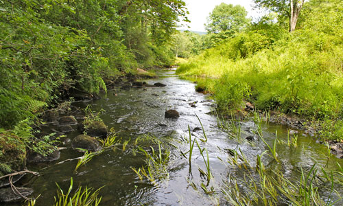
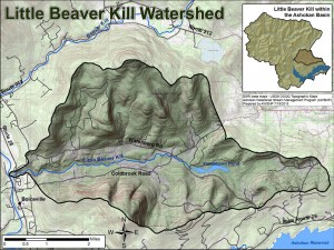
The Little Beaver Kill is a 9.8-mile stream, flowing east to west in the southeastern portion of the Ashokan Watershed, primarily in the Town of Woodstock. The 16.7 square-mile watershed is bound by the lower elevation mountains of Ohayo, Tonshi and Ticetonyk to the south, and Johns, Beetree, Tobias and Roundtop to the north. The Little Beaver Kill is a major tributary to the Esopus Creek and the last tributary to join the Esopus Creek before the Ashokan Reservoir. The creek flows through the hamlets of Montoma and Wittenburg and ends in Beechford near Boiceville in Ulster County, New York.
The Little Beaver Kill begins as two distinct forks, a south fork that flows from Ohayo Mountain and a north fork that drains Roundtop, Tobias, and Beetree mountains. The valley it occupies is much wider and less steep than many other Esopus Creek tributaries. The Little Beaver Kill is considered one of the more geomorphically stable tributaries in the watershed due to a lack of infrastructure influencing the creek along most of its length.
Unique features of the Little Beaver Kill include two, large in-stream ponds and a high occurrence of wetlands. These water bodies provide valuable habitat and flood storage, but also negatively affect sediment transport and may lead to increased water temperatures in the warmer summer months.
On the south fork of the headwaters, the Little Beaver Kill flows through Yankeetown Pond and an associated wetland complex. This area provides valuable habitat for reptiles, amphibians, and songbirds that rely on wetlands for their life cycle. Yankeetown Pond has a high density of water lilies, an invasive flowering plant that roots itself in the bottom sediment while its leaves and flowers float on the water surface. The Town of Woodstock Habitat Mapping project carried out by Hudsonia included the upstream portion of the Little Beaver Kill as it flowed through Yankeetown Pond. See Hudsonia’s report for more information on habitats and wildlife of the Little Beaver Kill watershed.
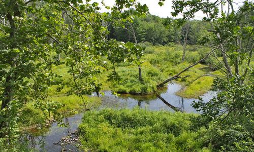
Downstream of the hamlet of Wittenburg, the Little Beaver Kill flows through a wetland complex and pond at the NYSDEC Kenneth L. Wilson Day Use Area and Public Campground. The pond at Kenneth Wilson Campground provides excellent fishing access for warmwater fish, including Largemouth Bass, Chain Pickerel, Yellow Perch, Sunfish, and Bullheads. Following Tropical Storm Irene, the Catskill Streams Buffer Initiative restored a section of the riparian buffer along the campground parking area.
The United States Geological Survey (USGS) operates a stream-gauging station at the downstream end of the Little Beaver Kill at Beechford. This gauge has been collecting continuous stream flow data since 1997. The stream gauge collects water stage (height) and relates it to discharge. The gauge transmits real-time data available on the web at: http://waterdata.usgs.gov/usa/nwis/uv?01362497
The Ulster County Soil & Water Conservation District has plans to carry out a stream feature inventory of the Little Beaver Kill in summer 2014. Once completed, a summary of findings and recommendations will be available on our website.