• Skip to primary navigation
  • Skip to main content
Ashokan Watershed Stream Management Plan logo

ashokanstreams

Ashokan Watershed Stream Management Plan

  • About Us
    • Our Team
    • Action Plans
    • Ashokan Watershed Stakeholder Council
    • Working Groups and Committees
    • Employment Opportunities
  • Areas of Focus
    • Assistance to Streamside Landowners
    • Enhancing and Protecting Water Quality
    • Floodplain Management
    • Improving Aquatic and Riparian Habitat
    • Increasing Public Access to Streams
    • Streamside Infrastructure
  • Explore the Watershed
    • Stream Recreation and Activities
    • Esopus Creek
    • Beaver Kill
    • Birch Creek
    • Broadstreet Hollow Creek
    • Bush Kill
    • Bushnellsville Creek
    • Fox Hollow Creek
    • Little Beaver Kill
    • Peck Hollow Creek
    • Stony Clove Creek
    • Warner Creek
    • Woodland Valley Creek
  • Projects & Funding
    • Featured Projects
    • SMIP Funding for Infrastructure Improvements
    • SMIP Project Insurance Requirements
    • Copyrights and Access to Information
    • Subcontractor Approval Policy
  • Conferences & Training
    • Catskill Environmental Research & Monitoring Conference (CERM)
    • Ashokan Watershed Conference 2017
    • Ashokan Watershed Weekend Events — Summer 2020
    • Ashokan Watershed Month
    • Stream Explorers Youth Adventure Day
    • Past Conferences
  • Publications & Resources
    • Technical Data & Resources
    • Stream Management Plans
  • News & Events
  • Contact Us
  • Show Search
Hide Search

No flooding, yet still the potential for geomorphic change

There was no major flooding during the last winter storm, but preliminary flow data show there could have been geomorphic adjustment in Ashokan streams.

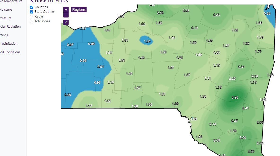
On December 23, 2022, AWSMP staff were monitoring for potential flooding as a storm moved through. Thankfully for the Ashokan watershed, the heaviest rain tracked north. However, Phoenicia still received the highest precipitation total at 3.4” (Times Union).  The NYS Mesonet shows a dark green “bulls’ eye” of high precipitation at Tannersville in Greene County, just north of the Ashokan watershed divide.

NYS Mesonet map of 14-day precipitation totals as of 1/3/2023.

Despite the heavy rains, most Ashokan streams didn’t reach “bankfull discharge.” Bankfull is the flow that completely fills the stable stream channel. Thus, any flow greater than bankfull is considered a flood.

Over time, near-bankfull flows do the most geomorphic work (erosion and sediment transport) because they are powerful enough to move substantial amounts of sediment and still occur relatively frequently.

The Little Beaver Kill was the only stream to exceed its estimated bankfull discharge of 915 cubic feet per second (cfs). The nearby Beaver Kill was the second highest, reaching 86% of bankfull, a flow still capable of minor flooding yet significant erosion.

Bar chart showing the percent estimated bankfull discharge (blue bar) for peak flows on 12/23/2022 for various Ashokan tributaries. Above the bars are the preliminary peak discharges in cubic feet per second.

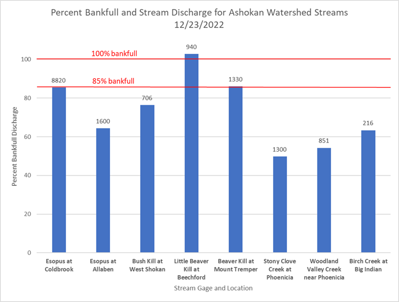
No major flooding or damage was reported in the Ashokan watershed.

Written by:
Tim Koch
Published on:
January 4, 2023

Categories: UncategorizedTags: Ashokan Watershed, bankfull, beaver kill, esopus creek, flood, geomorphology, Little Beaver Kill, mesonet, phoenicia, Streams

Ashokan Watershed Stream Management logo (in white)

Footer

Ashokan Watershed Stream Management Program

PO Box 667
3130 State Route 28
Shokan, NY 12481
845 688 3047
845 688 3130 (fax)

Copyright © 2023 ·

Keep In Touch

  • Facebook
  • Instagram
  • Twitter
  • YouTube
  • Homepage
  • About Us
  • Areas of Focus
  • Explore the Watershed
  • Projects & Funding
  • Conferences & Training
  • Publications & Resources
  • News & Events
  • Contact Us